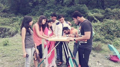
The plane table surveying is one of the fastest and easiest methods of surveying. Plotting of plans and field observations can be done at the same time in plane table surveying. It is useful for the following cases:
- It is best fitted for small-scale surveying i.e. any types of fields
- It is also used in surveying industrial areas where compass survey fails to perform
- It is often used to fill in details between stations fixed by triangulation method or theodolite traversing method.

Temporary Adjustments of The Plane Table
1. Centering
This process is to ascertain that the point on the ground is represented accurately on the paper. It is carried out with the help of plumbing fork and plumbing bob.The pointed end (at the upper hand) of the plumbing fork is kept on paper and at the other end, a plumb bob is fixed. The board is shifted manually until the bob hangs exactly over the peg of the station. This work can be tiresome but a prerequisite for any further activities.
2. Leveling
Leveling is done so that the drawing board remains parallel to the ground. It is done in the following three methods:
- ordinary tilting the board
- by ball and socket arrangement or
- by adjusting the legs of the tripod.
3. Orientation
The process by which the position occupied by the board at various survey stations are kept parallel is known as the orientation. In the plane table surveying, the whole table needs to be moved at several stations to complete a survey. Every time the table is moved one has to make sure that the new station is parallel to the previous one otherwise the lines drawn on paper will not represent the same lines on the field. Methods of orientation are:-
- Orientation by Magnetic Needle:
This method is used when it is not possible to bisect the previous station from the new station. This method is not much reliable and prone to errors due to variations of the magnetic field. - Orientation by Back Sighting:
This is a more reliable method. In this method, a particular line drawn from the previous station is drawn again from the new station. This process is called back-sighting. One does not necessarily have to draw the line the second time rather check if the new line superposes over the previous one or not.
{adselite}
Methods of Plane Table Surveying
Radiation
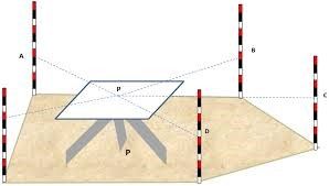
Method It is the simplest method of plane table surveying. This method is only effective if the whole surveying is to be done from one single station i.e. the table will be in such a position from where all the other points of the field are easily visible. The procedure is as follows:
- A point P is to be selected in such a fashion that all the other points ( A B C D E) are seen easily from P.
- Centering, leveling, and orientation must be done prior to surveying.
- At first, by putting the alidade on point P a line of sight for station A is to be drawn.
- After measuring the distance of PA on field, the measurement needs to be put on paper to a suitable scale.
- Similarly, points b, c, d, and e are obtained on paper by drawing lines of sight for stations B, C and D and measuring the distances PB, PC, PD and PE on ground respectively.
- Points a, b, c, d, and e are joined on paper, as shown in the figure.

Intersection
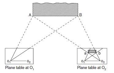
Method In previous method it was possible to measure every distance on the field manually. In case of a mountainous terrain or rough surface where distances cannot be taken physically, it is best to use intersection method. The procedure is:
- Two stations O1 and O2 are selected so that the points to be located on paper are easily seen from them.
- The baseline (o1o2) is plotted on the paper. This is done in the way below: The table can be centered and leveled at station O1 and then after orienting at station O2, the distance O1 O2 can be accurately measured and put up to some scale on the paper. The line o1o2 can be drawn to some scale on the paper and then the board can be adjusted from station O1 by back sighting at station O2.
- From station O1, rays for stations A, B are drawn etc.
- Now moving the table to the new station and orienting it again the rays of stations A, B are drawn etc.,
- The intersection of rays from stations O1 and O2 will give points a, b etc. on paper, as shown in the figure.

Traversing Method
This is more or less like the compass survey. It is used for running survey lines between stations, which have been previously fixed by other methods of survey, to locate the topographic details.
- The plane table is fixed at a location (say A)
- From that point, a sight is taken toward B and the distance AB is measured.
- The plane table is shifted to station B and sighted toward A (this is called back sighting). Distance BA was measured.
- The average distance between AB and BA are plotted to suitable scale on the drawing paper.
- Then the point C is sighted from B and the distance was measured. This process is repeated for all the stations.
- Conduct some check at uniform intervals. Finally, plot the traverse lines on the drawing sheet. Notice that back sighting was done only for the first two stations.

Resection Method
This method is suitable for establishing new stations at a place in order to locate missing details. It is the process of determining the previously plotted position of any peg station, by means of sight taken towards known points, the location of which has been plotted.
Resection method involves two different procedures as follows:
- The three-point problem
- The two-point problem
Two Point Problem
In this problem, two distinct points are selected whose location is known and plotted on the drawing paper. The two points are joined and bisected neatly. The bisecting point will be the new station.

